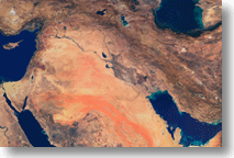
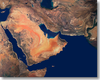
Iraq 278 m Resolution Satellite Imagery
278 m resolution satellite imagery of Iraq area is now available.
[Product Name: MISR Iraq 278m SP]

The entire area of Iraq is available for $1,999 only!
Registered against WGS84, this image can be combined with other vector data to create your own map.

(C) Clear Light Image Products, 2003

[Product Name:
MISR Iraq-Saudi-Afghan 278m SP]

Covering Lat 8-40 North, Lon 32-72 East, this image includes Saudi Arabia, Iran, Jordan, Israel, Afghanistan, Kuwait, as well as Iraq.

The size is 16000 x 12800 pixels.

In the same resolution of 278m, we also provide the US, Japan, Greece, and North and South Korea, and also the whole world in the 1km resolution of satellite imagery.

For more information, please click the following links:

278m satellite imagery

1km satellite imagery


(C) Clear Light Image Products, 2003

¡Data Sheet
Product Name MISR Iraq 278m SP
License Price $1,999 (USD)
Area Lat 24-40 North, Lon 32-56 East
Image Size 9600 x 6400 pixels
Sensor MISR (Terra)
Resolution 1 pixel = 278 m
Geometric Correction Yes iWGS84j
File Format(s) TIFF/JPG
Product Name MISR Iraq-Saudi-Afghan 278m SP
License Price $2,999 (USD)
Area Lat 08-40 North, Lon 32-72 East
Image Size 16000 x 12800 pixel
Sensor MISR (Terra)
Resolution 1 pixel = 278 m
Geometric Correction Yes iWGS84j
File Format(s) TIFF/JPG
¡For questions/orders, please mail to: info@clear-light-japan.com
Copyright 1998 - 2004 Clear Light Image Products. All rights reserved.