|

Here are a few examples in which Clear Light's satellite images are and can be used:
 |
Book |
Fantastic Earth/SHOGAKUKAN Inc. Japan |
|
|
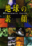 |
This book shows 40 scenes of the earth's "real face", seen from 700 km above the earth. Our globe image is contained inside.
3800 yen + tax
December 10, 1999
ISBN 4-09- 681281-1
Copyright 1997 (C) Shogakukan.
No reproduction or republication is allowed without written permission.
|

 |
Web site |
Our Spaceship EarthTM
"One Island In One Ocean...From Space"/Buckminster Fuller Institute |
|
|

|
Given a way to visualize the total planet with greater accuracy, humans aboard Spaceship Earth will be better equipped to address the challenges to humanity’s future.
The NOAA Earth 1 Km satellite image image was created by Clear Light Image Products.
|
|
Book |
Geography for Junior High/Teikoku-shoin Co., Ltc. |
|
|
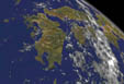 |
A school textbook.
Out work, a view from the space of the west part of Japan, is contained.
|
|
Poster |
Brightest Africa/Clear Light Image Products |
|
|
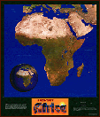 |
Brightest Africa is considered the birthplace of humanity. In this map, the national boundaries, along with the country and city names, have been drawn more finely than is usual in a map in order to blend into the terrain. This allows the physical features of the continent to be seen as uninterrupted from a distance while inviting a closer look to discover the political features and appreciate the high level of detail.
Can be ordered by e-mail: info@clear-light-japan.
Copyright (c) Jim Knighton/Clear Light Image Products, 1998
|
|
|
|
|
Web site |
Satellite Map of Tibet/Tibet Environmental Watch |
|
|
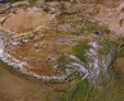 |
This site will be used to update important Tibetan environmental information as new data becomes available and to build upon the concept of a "Zone of Peace" as presented by His Holiness the Dalai Lama.
Our work, one of the collection of artworks using NOAA satellite earth image, is featured.
Copyright (c) Jim Knighton/Clear Light Image Products, 2000
|
|
Book |
Visualization of Natural Phenomena/Robert S. Wolff & Larry Yaeger |
|
|
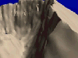 |
This integrated book/CD-ROM package allows users to interactively explore the techniques used in scientific visualization.Employing the image as the fundamental concept, the book covers a wide range of subjects under the broad heading of scientific visualization.
This terrain rendering of Mount St. Helens uses actual terrain data to show a simulated fly-through of the volcano after the explosion in 1980. The site shows its wonderful QuickTime and MPEG movies.
Courtesy of Jim Knighton, NASA/JPL
|
|
|
|